
Hey Everyone,
Waiting around in Wanaka to meet up with my Spanish friends in Queenstown paid off. We ended up going bungy jumping at the Nevis Valley site. At 134 meters (435 ft), it is the highest bungy jump you can do in Australasia. Also, now that I am not being charged by megabit for internet use, I can upload this awesome video:
I was so pumped with adrenaline that I can hardly remember the actual jump... I don't think it helps that it was over in only a few seconds, but it was the biggest rush I have ever experienced. I remember right before I jumped, standing on the platform and worrying more about not making a fool out of myself than the actual free-fall I was about to endure. There were a lot of people hanging out in the jumping structure watching. When she gave me a three count, all I could think about was my form and what I was going to yell (it was 'Geronimo,' but you can't hear it on the video to my dismay). It wasn't until I was in a horizontal swan dive looking down at the river far below– my toes leaving the platform– that what I was doing actually hit me!!! Once you look down at the sheer drop, head first, all alone, your body goes limp. Half-way through the jump, as my stomach bottomed out, I also remember thinking, "holy $&@%, I'm still falling!" I'm pretty sure I thought (and said to myself), "holy $&@%, countless times within the three minutes it took going down and coming back up again." As the bungy slowed me down, the blood rushed to my face and eyes. I remember closing my eyes tightly to reduce the discomfort. I was instructed to pull the foot release handle on my second time bouncing up. It was kind of scary bending myself to reach it and I remember fearing I would drop a few feet once my feet were released, but it wasn't bad. Never once did I doubt the equipment or the people working it.
What a crazy experience! I would totally do it again for a dollar, but not for NZ$250!
Tuesday, April 27, 2010
Thursday, April 22, 2010
Overnight Cruise on Doubtful Sound
One of the first things I wanted to do after I left Milford was go on an overnight cruise on Doubtful Sound. Doubtful Sound is another fjord within Fiordland National Park that is located south of Milford Sound. It is ten times the size of Milford Sound so an overnight cruise is the best way to explore the entire fjord. It is much more remote than Milford Sound since there is no road connecting it to the rest of the world. In order to get to Doubtful Sound, one must take a boat over Lake Manapouri, then a bus over Wilmot Pass to get to your cruise boat that is harbored in Deep Cove. The fjord has three arms– two of which were explored on our cruise– and it connects to Bradshaw Sound, at the end of which is where we anchored for the night.
 We stayed the night before at the Te Anau Lake View Holiday Park in our campervan. It was the first time ever that we slept in our van. It is not the biggest campervan on the planet, but it is the perfect medium for versatility and comfort.
 From Te Anau, it was only a 20-minute drive to Manapouri where the Real Journeys office is located (and our departure point). This is the first boat we took. It was about a 45-minute boat ride in this thing, which cruised at about 25 knots, to the west arm power station and visitor center.
 The captain behind me was named Andrew. He kind of looked like the Andrew who sings for Fatt Finger, the Chicago band I used to play in.
 This picture is from the top deck of that boat. Andrea’s hair is demonstrating why Andrew warned everyone to hold onto their hats.
 This is the power station that sucks water from Lake Manapouri under the mountain, and drains into Deep Cove of Doubtful Sound to create electricity. You can take a tour of the power station, but it wasn’t included on our trip; it’s only included on the day cruises.
 This is the bus that took us over Wilmot Pass. I was sad it wasn’t one of the Real Journeys buses that looks like a caterpillar.
 Here we are on the look-out from Wilmot Pass looking down at Deep Cove of Doubtful Sound.
 This is our cruise boat. It was the perfect size. Still fun to explore, but not so big that you feel like you are on a cattle drive. I think it had between 6 and 8 doubles, the same amount of twins, and maybe four quad rooms.
 This is Andrea and my room. Real Journeys gave me a great discount for being such a good salesman or whatever. We had our own bathroom complete with shower, toilet that made interesting mechanical noises when flushed, and a sink so tiny it was impossible to wash your face without getting water all over the floor.
 This is the view from our door down the deck.
 Real Journeys has an open bridge policy so anyone can walk onto the bridge at any time and talk to the captain and ask him questions.
 Here Andrea and I are enjoying the sun... and wind.
 This is Andrea sitting next to the nature guide. Periodically throughout the cruise, he would comment on what we were seeing, talking into his cordless microphone. He would mostly sit on the front deck or stand on the bridge. The captain of the ship would also make comments.
Later that afternoon, we stopped at the end of the Crooked Arm of Doubtful Sound and went kayaking for about 45 minutes. The crew hauled a bunch of kayaks over the back of the ship and we stepped into them. It was funny because our personal crafts didn’t have any rudder, nor did we get any direction on how to control them, so we were bouncing off of each other and zig-zagging along the shore. It was a great way to break the ice between strangers.
After kayaking, people went swimming, but I couldn’t get myself to do it. It was so cold and I couldn’t imagine jumping in without a warm sun or sauna to warm me up immediately afterward. I was pretty exhausted after kayaking so we took a short 30-minute nap that probably turned into an hour nap.
 When we woke up, we immerged on deck to find that the sales were unrolled for some reason. I don’t really understand how they could provide any thrust considering there was no boom and I’m not sure if the boat had a keel. They looked pretty cool though.
 Dinner was a delicious buffet of pasta, salad, tartlets, freshly cut beef and lamb, and much more. We bought a bottle of Montana Pinot Noir, which we enjoyed. After dinner, the nature guide gave a slide show about the wildlife of Fiordland. It was very interesting. I didn’t want to interrupt him with camera flashes so I took this picture after his presentation was done. This room is the “observation lounge,” which is located right below the bridge. It was a good place to look out at the fjord the next day when it was rainy. It also had a screen that showed our GPS location with a line that showed where we had already sailed.
After the slide show, we watched Grumpier Old Men on my laptop and went to bed.
 The next morning we were awoken at 6:30 by the engines firing up and had to get up to eat breakfast because it was only served between 7:00 and 8:00.
 It was a delicious continental breakfast with creamy, garlic scrambled eggs, bacon, hash browns, baked beans, and fluffy, crispy croissants. Once we were done with breakfast, our beds were already being turned over so we couldn’t go back to bed, but I’m glad we didn’t because there was more of the fjord to see.
 This is at the end of Hall Arm. We stopped there, turned off the engines, and everyone stood in silence for a few minutes to get a sense of our remoteness and take in the sounds of nature.
 Here our nature guide stood out in the rain by himself. I thought it was funny how no one else was out there with him. We all stayed warm and dry as he spoke to us over the loud speakers around the ship through his wireless microphone. He was kiwi and really enjoyed making fun of Australia. It was funny.
 Here is our ship the Fiordland Navigator anchored at Deep Cove after our cruise was complete.
 Here Andrea is looking adorable in front of the display in the visitor center at the West Arm Power Station waiting to board our boat to take us back to Manapouri.
The overnight cruise on Doubtful Sound was truly wonderful! It was one of those things you only get to do once– where you are pampered and feel like royalty, just for a day. Andrea and I agreed that we didn’t want it to end and we were thinking of hiding somewhere on the ship living there as phantoms that haunt it at nighttime by eating their food, drinking their booze, and playing the piano.
Goodbye Milford :(
Hey everyone!
There have been some happy times and some sad times since my last blog post. The sad times being the fact that my time spent in Milford have come to an end. Andrea and I had to pack up all of our stuff, fit it all in the van, clean my room, say our goodbyes (which was really really difficult), and leave… possibly for ever…
 As I drove away, I couldn’t help but think about all the fun times I had during my 5-month stay living and working at Milford Sound Lodge. I made some very strong friendships and created memories I will never forget: our road trip to Dunedin, winning the Milford Treasure Hunt, Christmas and new years celebrations, Climbing Mitre Peak, the Milford Olympics and my poor gumboot toss (to say the least), swimming in secret places, the Routeburn Track, Milford Dress-up, the Milford End-of-the-Season Ball, and much much more.
That place is truly special and it’s not just because of the indescribable beauty, but also because of the people working and living in the closely-knit community of less than 200. When I came to New Zealand, one of the things I wanted to do most was to make friends from around the world. Over the past five months, I did just that. For the rest of my life, I will keep in touch with my new friends from New Zealand, the UK, Canada, Mexico, Brazil, Chile, Germany, Spain, USA, Holland, and more. Thanks for a great time, guys! I really lucked out coming to Milford and meeting you all.
I also wanted to thank my lodge coworkers/friends for my goodbye gifts. They put together a goodbye card that was constructed out of a Southern Discoveries brochure, but with the lodge brochure cut up and glued to it. Then, everyone wrote a little note to me on it. Jamie also made a large batch of his outstanding oatmeal raisin cookies (which, might I add, are almost gone already).
Cheers Guys!
Hike to the Bottom of Bowen Falls
Of the two secret trails to Bowen Falls, the one to the bottom of the waterfall is less secret than the one to the top. The reason is because the trail to the bottom used to be open to the public before it was closed due to dangerous rock falls and tree avalanche risks. The interesting thing is that the trail isn’t that long since Bowen falls is located just around the corner from Milford Warf.
 This is the beginning of the trail. You can tell how it used to be traveled often (open to the public) since it is paved with cement. It has since been closed by a locked gate, but it is pretty easy to climb over. The rock cliff to the immediate right is pretty steep which is where the danger comes from, but it is covered in dripping moss that is really beautiful and full of wet green life. I like to imagine it is inhabited with millions of sea monkeys wearing futuristic spandex outfits. We had a German lodge guest stay for two weeks studying moss for his post doctorate research. I wish I could have told him to go on this trail, but I was still unaware back then.
 Here is another view of the rock cliff the trail runs along. On wet days, waterfalls like this one appear all around the fiord. It’s like a water fun park, but without the plastic slides, thousands of people, warm weather, or lifeguards.

Eventually, the trail ducks into the forest where damage is evident from the storm we had about a week before. The thunderous roar of the waterfall grows in volume as you hike onward until…

You are ejected out of the woods into the blowing mist of Bowen falls. Since it was raining, the falls was even bigger than normal so it was impossible to stay dry anywhere within the great vicinity of the falling water feature. In this picture, I am trying to stand as vertically straight as possible but, as you can see, I need to work on my arm positioning.

This is not the grave of Frankenberry or Count Chocula, Nope. It’s actually the grave of William Rath… something (the gravestone was old and hard to read). William Rath… something sure had a great taste for the placement of his own grave. Seriously!
I wasn’t able to take a lot of pictures around the falls because it was too wet and I worried I might ruin my nice camera again.
 On the way back, we veered onto a side trail that lead us to the beach. From there, we could hike around and see the waterfall from a distance.

and with the position of the afternoon sun, it was the perfect recipe for rainbow creations off of the waterfall mist. This is only one of the ten thousand pictures I took of this exact scene. It was so beautiful that I think my brain malfunctioned and the only way I could cope was to just keep taking pictures.

Here is a random picture of Milford Warf. I had to balance on top of a metal pole to take this picture because I needed to elevate myself enough to see all the boats from a higher vantage point.
Word to your mother.
Tuesday, April 13, 2010
Lake Marion/Gertrude Saddle (Camping and Freezing)
Andrea and I did a bunch of fun things on my last days off and I am just getting around to posting them on this blog. We got a bunch of rain and you know what that does to satellite internet.
We planned our travels in coordination with Rowan hiking to Lake Adelaide by himself. We dropped him off on Hollyford Road and then, because we were passing by, decided to stop and do the Lake Marian hike.
 I like the word "gantry." It sounds like a place you keep a lot of birds... or food? Right after we passed this sign some old people told us that they hiked 3/4 of the way and then turned back. He couldn't hike the entire way because he just got a new hip. I was thinking "well, I better get up there before I need a new hip."
 Here Andrea is looking adorable as she crosses the river on this rickety bridge. It was fun to jump up and down on because it was springy. It reminded me of the part in Indiana Jones and the Temple of Doom where the Shaman guy throws his friend off the broken bridge and he gets eaten by alligators. I'm not sure what the river is called, but since it was in Hollyford Valley, I would guess it to be the Hollyford River.
 Here Andrea and I are at the food pantry or whatever it's called. The water here is really really clear and blue!
 After hiking for about an hour, we found that the trail disappeared into a body of water. Looking up, we realized that we had arrived at Lake Marian. The water was as green as the Emerald City from the Wizard of Oz. Although the sun was out, it was still as cold as the Emerald City from the Wizard of Oz. Here Andrea is looking adorable standing in front of the Emerald Cit... I mean Lake Marian.
There wasn't any place to hike around the lake and I was kind of disappointed. I later realized that the water was super high for some reason and so the small beach that one usually can use to navigate around the lake was under great amounts of water. So, Andrea and I just bush wacked and found a place to sit, rest, and nap in the warm sun.
 Here we are at the bird gantry again. Hiking down is a lot harder on your knees. Hiking up is harder on your muscles, heart, and lungs. Mr. Good Body says, "eat an apple a day, you idiot."
 Then, it was onward down Milford Road to camp in Gertrude Valley for the night. I had no idea where we were going to camp and we were running out of day light. I should mention that we were originally planning on camping on the saddle, but we were kind of tired after hiking up to Lake Marian. I'm also glad we didn't camp on the saddle because it was windy and very very very cold. We probably would have shivered and not slept a wink.
 I didn't remember this beautiful clear body of water at the beginning of the hike last time I did it several months before so I needed to photograph it. It looks like a small slice of tropical ocean water except much much colder.
As we walked into the valley, we were greeted by some guy carrying some sticks. I thought he might be a DOC employee and I was thinking camping in the valley wasn't allowed so I tried to hide the fact that we were camping by asking about his sticks quickly after he asked us where we were going. He wasn't a DOC worker by the way.
 This is where we ended up camping in Gertrude Valley. It was very difficult to find a spot that was far away from the trail, but also flat, bush-free, level, and not in a wash area. Our small tent barely fit in this place. I got to sleep with the rock under my back. When I showed this photo to my manager (and camping expert), he gasped because I guess it was in a rock tumbling zone. We didn't hear any rocks tumbling though...
 Sleeping that night was very very cold and windy. We wore almost all of our clothes inside our sleeping bags, but I was still slightly cold. Normally you can trap the heat inside the tent, but the wind was constantly cycling in new cold air. This picture shows the frost on my pack and my travel pillow (that I didn't use because it was soaking wet from my water bladder rupturing the day before).
 Here Andrea is looking adorable standing in front of the large rock we hid our packs behind. We left our packs behind so we could hike lighter (and easier) up to the saddle.
 We brought along a small tripod so we could take pictures with both of us in them.
 Here we are on the saddle. The view is beyond words from there, but I will try to describe it with one I made up: zerb. Right behind us is a gigantic drop (I wish I knew how tall it was). It would be a great place to go hang gliding or to test out your new flying invention.
 Here Andrea is looking adorable sitting on the saddle with her eyes closed. She is imagining she is flying the Wright flying machine at Kitty Hawk, North Carolina in 1903.
 This is Gulliver Valley and you can see Milford Sound in the distance.
 Here we are grazing on the succulent grasses that can be found on the saddle of Gertrude. And by grazing, I just mean sitting.
 On our way up, the sun wasn't shining on us at all, but on the way down, it was high enough to light up some good pictures. It is really difficult to judge distance in the shot, but that body of water behind us is not a puddle, but a large lake called "Black Lake." We didn't swim in it because we would have died of hypothermia.
 This is us in front of Black Lake as seen looking up the mountain. I realized very quickly that the best pictures are taken when the subject is illuminated from the front. Otherwise, you look evil and sad.
 Here we are in front of Black Lake as seen looking back up at the Saddle.
And then it was about an hour hike down to our car where we ate the rest of our peanut butter and honey sandwiches and oranges before driving Rowan's stick-shift car back to Milford. Oh yeah, I should mention that we took Rowan's car because, as we were leaving the lodge in my van, we realized that it had a flat tire.
Remember my last entry about Skipper's Canyon? Well, I'm glad the flat didn't happen there because it took four people to fix it. I would have truly been screwed. Here's how screwed I would have been: I would have been stranded in a remote location– no one knowing where I was– with a jack but no tools with which to work the jack, no cell phone coverage, I would not have been able to pick up Andrea at the Queenstown airport on time, nor been able to call her to inform her of my impending tardiness, and I could have easily missed work the next day. I really need to buy some jack working tools (one of the previous owners must have decided to keep them), and also a new tire...
We planned our travels in coordination with Rowan hiking to Lake Adelaide by himself. We dropped him off on Hollyford Road and then, because we were passing by, decided to stop and do the Lake Marian hike.
 I like the word "gantry." It sounds like a place you keep a lot of birds... or food? Right after we passed this sign some old people told us that they hiked 3/4 of the way and then turned back. He couldn't hike the entire way because he just got a new hip. I was thinking "well, I better get up there before I need a new hip."
 Here Andrea is looking adorable as she crosses the river on this rickety bridge. It was fun to jump up and down on because it was springy. It reminded me of the part in Indiana Jones and the Temple of Doom where the Shaman guy throws his friend off the broken bridge and he gets eaten by alligators. I'm not sure what the river is called, but since it was in Hollyford Valley, I would guess it to be the Hollyford River.
 Here Andrea and I are at the food pantry or whatever it's called. The water here is really really clear and blue!
 After hiking for about an hour, we found that the trail disappeared into a body of water. Looking up, we realized that we had arrived at Lake Marian. The water was as green as the Emerald City from the Wizard of Oz. Although the sun was out, it was still as cold as the Emerald City from the Wizard of Oz. Here Andrea is looking adorable standing in front of the Emerald Cit... I mean Lake Marian.
There wasn't any place to hike around the lake and I was kind of disappointed. I later realized that the water was super high for some reason and so the small beach that one usually can use to navigate around the lake was under great amounts of water. So, Andrea and I just bush wacked and found a place to sit, rest, and nap in the warm sun.
 Here we are at the bird gantry again. Hiking down is a lot harder on your knees. Hiking up is harder on your muscles, heart, and lungs. Mr. Good Body says, "eat an apple a day, you idiot."
 Then, it was onward down Milford Road to camp in Gertrude Valley for the night. I had no idea where we were going to camp and we were running out of day light. I should mention that we were originally planning on camping on the saddle, but we were kind of tired after hiking up to Lake Marian. I'm also glad we didn't camp on the saddle because it was windy and very very very cold. We probably would have shivered and not slept a wink.
 I didn't remember this beautiful clear body of water at the beginning of the hike last time I did it several months before so I needed to photograph it. It looks like a small slice of tropical ocean water except much much colder.
As we walked into the valley, we were greeted by some guy carrying some sticks. I thought he might be a DOC employee and I was thinking camping in the valley wasn't allowed so I tried to hide the fact that we were camping by asking about his sticks quickly after he asked us where we were going. He wasn't a DOC worker by the way.
 This is where we ended up camping in Gertrude Valley. It was very difficult to find a spot that was far away from the trail, but also flat, bush-free, level, and not in a wash area. Our small tent barely fit in this place. I got to sleep with the rock under my back. When I showed this photo to my manager (and camping expert), he gasped because I guess it was in a rock tumbling zone. We didn't hear any rocks tumbling though...
 Sleeping that night was very very cold and windy. We wore almost all of our clothes inside our sleeping bags, but I was still slightly cold. Normally you can trap the heat inside the tent, but the wind was constantly cycling in new cold air. This picture shows the frost on my pack and my travel pillow (that I didn't use because it was soaking wet from my water bladder rupturing the day before).
 Here Andrea is looking adorable standing in front of the large rock we hid our packs behind. We left our packs behind so we could hike lighter (and easier) up to the saddle.
 We brought along a small tripod so we could take pictures with both of us in them.
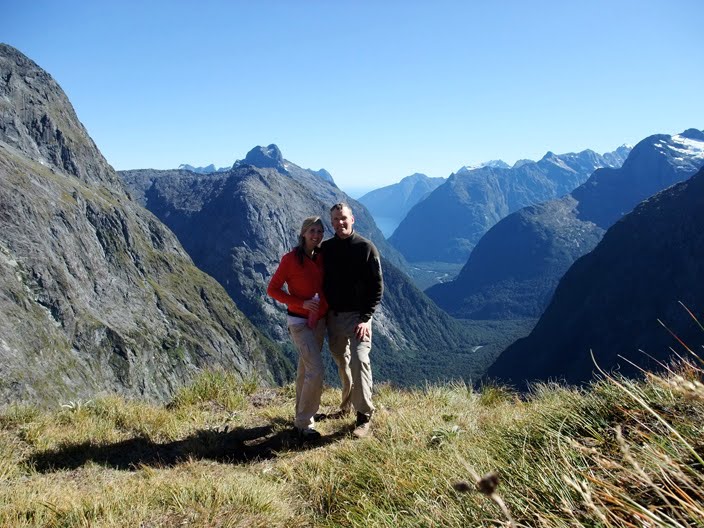 Here we are on the saddle. The view is beyond words from there, but I will try to describe it with one I made up: zerb. Right behind us is a gigantic drop (I wish I knew how tall it was). It would be a great place to go hang gliding or to test out your new flying invention.
 Here Andrea is looking adorable sitting on the saddle with her eyes closed. She is imagining she is flying the Wright flying machine at Kitty Hawk, North Carolina in 1903.
 This is Gulliver Valley and you can see Milford Sound in the distance.
 Here we are grazing on the succulent grasses that can be found on the saddle of Gertrude. And by grazing, I just mean sitting.
 On our way up, the sun wasn't shining on us at all, but on the way down, it was high enough to light up some good pictures. It is really difficult to judge distance in the shot, but that body of water behind us is not a puddle, but a large lake called "Black Lake." We didn't swim in it because we would have died of hypothermia.
 This is us in front of Black Lake as seen looking up the mountain. I realized very quickly that the best pictures are taken when the subject is illuminated from the front. Otherwise, you look evil and sad.
 Here we are in front of Black Lake as seen looking back up at the Saddle.
And then it was about an hour hike down to our car where we ate the rest of our peanut butter and honey sandwiches and oranges before driving Rowan's stick-shift car back to Milford. Oh yeah, I should mention that we took Rowan's car because, as we were leaving the lodge in my van, we realized that it had a flat tire.
Remember my last entry about Skipper's Canyon? Well, I'm glad the flat didn't happen there because it took four people to fix it. I would have truly been screwed. Here's how screwed I would have been: I would have been stranded in a remote location– no one knowing where I was– with a jack but no tools with which to work the jack, no cell phone coverage, I would not have been able to pick up Andrea at the Queenstown airport on time, nor been able to call her to inform her of my impending tardiness, and I could have easily missed work the next day. I really need to buy some jack working tools (one of the previous owners must have decided to keep them), and also a new tire...
Wednesday, April 7, 2010
Skipper's Canyon
Hey Everyone,
I wanted to tell you a tale of something I did the night before picking Andrea up at the Queenstown airport. I wanted to test the van/bed out for the first time and save some money I would have spent staying in a hostel (sharing it with at least three other people). I looked at the Department of Conservation (DOC) brochure to find an interesting camping ground I could use in the Queenstown area and I came across the Skipper's Canyon camp ground, which is listed as being 17km away from Queenstown. I thought that it sounded perfect.
After work on April 31st, I drove to Queenstown, ate dinner at @Thai, the restraint (which was very very good, by the way), and saw Alice in Wonderland (I should mention that that movie is NOT worthy of that Title), and around 10:00 pm, I set out to find this camping ground. I drove up the mountain towards Cornet Peak and eventually found Skipper's Canyon Road, which is a dirt road. Not too far in, I was greeted by this sign:
 The wooden, painted man next to the sign was kind of scary at night because it looked like a real person until I got closer to it. For those who can't read the sign on the tiny picture, allow me to quote it for you:
 This is what it looked like. I was the only person there, completely isolated. I don't think it was my ultimate destination because the brochure said it had a toilet, which this place did not have. Who knows how much further it would have been to get to the camping ground.That structure in the picture just held some displays about the history of the area– lots of gold mining around there; no toilet. No problem.
 I left at about 8:00am, I think, and was able to take a bunch of beautiful pictures of Skipper's Canyon along the way. It was pretty funny considering I had driven past all of this the night before without having any idea of the beauty I was missing. Why is it that you have to get up at the earliest time possible to take the most beautiful pictures?
 Here's a cool one-lane bridge that is part of the road.
 Now that it is approaching fall, the sun is staying to the north and so there are longer, more frequent shadows cast on the landscape.
 These two chimneys are all that remain of an old hotel called The Welcome Home Hotel. The hotel was family owned between 1908 to 1942 and was frequented by minors, tourists, and shepherds that passed by on their way to Queenstown. When I passed by this in the dark, the night before, I thought they were grave stones and it was really eerie.
 I guess in New Zealand, sheep just materialize out of nowhere and graze. They must be able to travel between dimensions. They might be radioactive too, so don't touch them! While driving at night, there was no one else on the road, which is what you want when you're driving on a treacherous one-lane road. That day, as it got later, I was met by caravans of tour buses and trucks on an increasing basis. Just beyond this picture, I had to back up and let 6 rafting buses through.
I survived! Yay! Then my tire popped several days later. I'm very glad it waited until after the remote scary road.
The End
I wanted to tell you a tale of something I did the night before picking Andrea up at the Queenstown airport. I wanted to test the van/bed out for the first time and save some money I would have spent staying in a hostel (sharing it with at least three other people). I looked at the Department of Conservation (DOC) brochure to find an interesting camping ground I could use in the Queenstown area and I came across the Skipper's Canyon camp ground, which is listed as being 17km away from Queenstown. I thought that it sounded perfect.
After work on April 31st, I drove to Queenstown, ate dinner at @Thai, the restraint (which was very very good, by the way), and saw Alice in Wonderland (I should mention that that movie is NOT worthy of that Title), and around 10:00 pm, I set out to find this camping ground. I drove up the mountain towards Cornet Peak and eventually found Skipper's Canyon Road, which is a dirt road. Not too far in, I was greeted by this sign:
 The wooden, painted man next to the sign was kind of scary at night because it looked like a real person until I got closer to it. For those who can't read the sign on the tiny picture, allow me to quote it for you:
- Historic Skipper's Road is narrow and prone to slips
- Caravans and trailers are not suitable on this road
- In winter, snow can close the road
- Some vehicles are not insured past this point
- No turn around for 6km
- NO EXIT
 This is what it looked like. I was the only person there, completely isolated. I don't think it was my ultimate destination because the brochure said it had a toilet, which this place did not have. Who knows how much further it would have been to get to the camping ground.That structure in the picture just held some displays about the history of the area– lots of gold mining around there; no toilet. No problem.
 I left at about 8:00am, I think, and was able to take a bunch of beautiful pictures of Skipper's Canyon along the way. It was pretty funny considering I had driven past all of this the night before without having any idea of the beauty I was missing. Why is it that you have to get up at the earliest time possible to take the most beautiful pictures?
 Here's a cool one-lane bridge that is part of the road.
 Now that it is approaching fall, the sun is staying to the north and so there are longer, more frequent shadows cast on the landscape.
 These two chimneys are all that remain of an old hotel called The Welcome Home Hotel. The hotel was family owned between 1908 to 1942 and was frequented by minors, tourists, and shepherds that passed by on their way to Queenstown. When I passed by this in the dark, the night before, I thought they were grave stones and it was really eerie.
 I guess in New Zealand, sheep just materialize out of nowhere and graze. They must be able to travel between dimensions. They might be radioactive too, so don't touch them! While driving at night, there was no one else on the road, which is what you want when you're driving on a treacherous one-lane road. That day, as it got later, I was met by caravans of tour buses and trucks on an increasing basis. Just beyond this picture, I had to back up and let 6 rafting buses through.
I survived! Yay! Then my tire popped several days later. I'm very glad it waited until after the remote scary road.
The End
Subscribe to:
Posts (Atom)