
We planned our travels in coordination with Rowan hiking to Lake Adelaide by himself. We dropped him off on Hollyford Road and then, because we were passing by, decided to stop and do the Lake Marian hike.
 I like the word "gantry." It sounds like a place you keep a lot of birds... or food? Right after we passed this sign some old people told us that they hiked 3/4 of the way and then turned back. He couldn't hike the entire way because he just got a new hip. I was thinking "well, I better get up there before I need a new hip."
 Here Andrea is looking adorable as she crosses the river on this rickety bridge. It was fun to jump up and down on because it was springy. It reminded me of the part in Indiana Jones and the Temple of Doom where the Shaman guy throws his friend off the broken bridge and he gets eaten by alligators. I'm not sure what the river is called, but since it was in Hollyford Valley, I would guess it to be the Hollyford River.
 Here Andrea and I are at the food pantry or whatever it's called. The water here is really really clear and blue!
 After hiking for about an hour, we found that the trail disappeared into a body of water. Looking up, we realized that we had arrived at Lake Marian. The water was as green as the Emerald City from the Wizard of Oz. Although the sun was out, it was still as cold as the Emerald City from the Wizard of Oz. Here Andrea is looking adorable standing in front of the Emerald Cit... I mean Lake Marian.
There wasn't any place to hike around the lake and I was kind of disappointed. I later realized that the water was super high for some reason and so the small beach that one usually can use to navigate around the lake was under great amounts of water. So, Andrea and I just bush wacked and found a place to sit, rest, and nap in the warm sun.
 Here we are at the bird gantry again. Hiking down is a lot harder on your knees. Hiking up is harder on your muscles, heart, and lungs. Mr. Good Body says, "eat an apple a day, you idiot."
 Then, it was onward down Milford Road to camp in Gertrude Valley for the night. I had no idea where we were going to camp and we were running out of day light. I should mention that we were originally planning on camping on the saddle, but we were kind of tired after hiking up to Lake Marian. I'm also glad we didn't camp on the saddle because it was windy and very very very cold. We probably would have shivered and not slept a wink.
 I didn't remember this beautiful clear body of water at the beginning of the hike last time I did it several months before so I needed to photograph it. It looks like a small slice of tropical ocean water except much much colder.
As we walked into the valley, we were greeted by some guy carrying some sticks. I thought he might be a DOC employee and I was thinking camping in the valley wasn't allowed so I tried to hide the fact that we were camping by asking about his sticks quickly after he asked us where we were going. He wasn't a DOC worker by the way.
 This is where we ended up camping in Gertrude Valley. It was very difficult to find a spot that was far away from the trail, but also flat, bush-free, level, and not in a wash area. Our small tent barely fit in this place. I got to sleep with the rock under my back. When I showed this photo to my manager (and camping expert), he gasped because I guess it was in a rock tumbling zone. We didn't hear any rocks tumbling though...
 Sleeping that night was very very cold and windy. We wore almost all of our clothes inside our sleeping bags, but I was still slightly cold. Normally you can trap the heat inside the tent, but the wind was constantly cycling in new cold air. This picture shows the frost on my pack and my travel pillow (that I didn't use because it was soaking wet from my water bladder rupturing the day before).
 Here Andrea is looking adorable standing in front of the large rock we hid our packs behind. We left our packs behind so we could hike lighter (and easier) up to the saddle.
 We brought along a small tripod so we could take pictures with both of us in them.
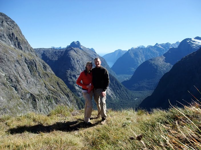 Here we are on the saddle. The view is beyond words from there, but I will try to describe it with one I made up: zerb. Right behind us is a gigantic drop (I wish I knew how tall it was). It would be a great place to go hang gliding or to test out your new flying invention.
 Here Andrea is looking adorable sitting on the saddle with her eyes closed. She is imagining she is flying the Wright flying machine at Kitty Hawk, North Carolina in 1903.
 This is Gulliver Valley and you can see Milford Sound in the distance.
 Here we are grazing on the succulent grasses that can be found on the saddle of Gertrude. And by grazing, I just mean sitting.
 On our way up, the sun wasn't shining on us at all, but on the way down, it was high enough to light up some good pictures. It is really difficult to judge distance in the shot, but that body of water behind us is not a puddle, but a large lake called "Black Lake." We didn't swim in it because we would have died of hypothermia.
 This is us in front of Black Lake as seen looking up the mountain. I realized very quickly that the best pictures are taken when the subject is illuminated from the front. Otherwise, you look evil and sad.
 Here we are in front of Black Lake as seen looking back up at the Saddle.
And then it was about an hour hike down to our car where we ate the rest of our peanut butter and honey sandwiches and oranges before driving Rowan's stick-shift car back to Milford. Oh yeah, I should mention that we took Rowan's car because, as we were leaving the lodge in my van, we realized that it had a flat tire.
Remember my last entry about Skipper's Canyon? Well, I'm glad the flat didn't happen there because it took four people to fix it. I would have truly been screwed. Here's how screwed I would have been: I would have been stranded in a remote location– no one knowing where I was– with a jack but no tools with which to work the jack, no cell phone coverage, I would not have been able to pick up Andrea at the Queenstown airport on time, nor been able to call her to inform her of my impending tardiness, and I could have easily missed work the next day. I really need to buy some jack working tools (one of the previous owners must have decided to keep them), and also a new tire...


