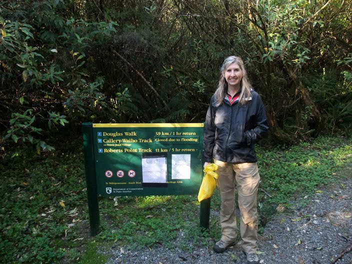
Once I heard that I got an interview for a job at Treble Cone, Andrea and I went to Wanaka and spent about a week searching for jobs for Andrea and hanging out with Filipe, my friend from Milford. Once my interview was over, we decided to leave and continue on our travels immediately. This took us up the west coast where the glaciers, which have been one of my most anticipated attractions, are located. There are two glaciers that are accessible from highway 6, the first being the Fox glacier, which is the smaller of the two, but less populated with tourists. It is for this reason that we decided to explore it. Both glaciers have roads leading up to the foot of the ice, but if you want to get onto it and explore it by foot, you need to pay for a guided walk. We were initially planning on just doing a half-day trip, but a couple sharing the holiday park with us recommended the full-day trip since you get more for your money.

The first thing you do is get fitted for boots and crampons. My feet were the perfect size for NONE of the boots to fit me so they gave me a pair that looked like they were hand made by a monkey and then worn every day for 35 years. They didn't fit my feet at all and I felt like I was wearing high healed women's shoes. I decided to go get my own boots and hope the crampons would fit them. To my luck they did. We also borrowed hats, mittens, and backpacks for our extra layers. In this picture, our guide, Jeff, is showing us where we will be hiking for the day.

Once off of the shuttle bus, we stopped next to the big river that flows from under the glacier. Jeff explained to us that this river can be dangerous because ice can break of and dam up the river but then give way and cause a massive serge that can surprise unsuspecting tourists. For that reason, there are fences all around keeping people safe distances from the water and the falling ice. These fences are disappointingly far from the glacier itself and as a result, tourists often jump over them and hike closer. I guess every year there are injuries that occur and a couple years ago, someone was crushed by falling ice.

This is one of the Fox Glacier Guiding staff members searching for falling rocks. They have to be there before and after groups pass to make sure they don't get hit by...

rock slides from this slip area. I guess very large boulders can come barreling down at random times and it can be very dangerous.

Here, Jeff shows us pieces of ice that have broken off of the glacier and have washed well down stream. Drinks anyone?

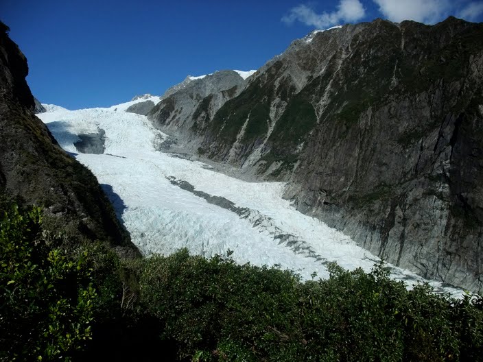
Our hike took us up the left side of the glacial valley and then down onto the glacier, steering us clear of the dangerous, crumbling glacial foot. This picture is looking back down the valley. At this time of year, the valley doesn't get much direct sunlight. As a result, the sunglasses I brought were completely useless.

Part of the hike passed narrow, treacherous areas. If you look in the background, you can see another group in the scariest spot. Our guides made sure we held onto the hand rail with both hands and did not give into the temptation to take pictures until after we were past the danger zone.

Once we got close to the ice, it was time to take out our crampons out of our packs and put them on our feet. There was also a pile of walking sticks you could take. This picture demonstrates what one might see if they were hiking on a glacier. By the way, I wouldn't recommend anyone taking the walking stick. It ended up getting in the way most of the time. I would have much rather had a free hand for taking pictures. Plus, the guides end up cutting steps in the ice for easy walking anyway.

Both guides had large axes that they used to chop steps into the ice. Throughout the entire day, as we explored the glacier, we had to sit and wait for them to chop steps. Andrea and I felt as though these steps were often not needed since we wore crampons and could walk up fairly steep slopes easily. The overall pace of the group was very slow and we ended up feeling cold as we stood around a lot. I wished we would have done more walking and less talking. I think most of the others agreed.

We had to walk in single file so our guides could keep track of us. We did a good job of taking turns leading or tailing.

I was proud of this picture. Even though I took it blindly, I still got everyone in it. Plus, I managed to smile handsomely.

This is the large blue hole we had to explore. There were several holes we took turns looking into, but this one was the biggest. Surprisingly, there were very few deep crevasses that I could find. I never saw any that dropped into darkness that were big enough to hold an unlucky plummeting person.

Apparently the red sands of Australia are swept up by the wind and carried across the Tasman Sea and dropped onto the ice of the west coast glaciers. Here's proof!

At the end of the day, the setting sun provided some beautiful lighting for some glacier hiking pictures.

We were greeted by a pesky Kea on our way back. This was very nearly an awesome picture, but it wasn't in focus. Pooh!

This is what the foot of a glacier looks like when it is lit by the setting sun. This picture was taken near the "no picture zone" alone the side of the valley.

What setting sun you ask? This one.

...and the tired glacier hikers lived happily ever after.

After the hike, it was on the the local pub where I tried a local delicacy called whitebait. It's some kind of fish.

 Our next stop while traveling up the west coast was the pancake rocks. I must admit that I hadn't done my research so I was expecting something completely different than what we actually saw there. I also had no idea where they were until I eventually passed several signs advertising their approaching location. That being said, the pancake rocks are one of the countless wonders of the country and undoubtedly worth stopping for. How they were formed is still a scientific mystery, although they know they are some kind of sedimentary rock. Sedimentary rock is formed on the ocean floor as shells, minerals, and muck settles to the bottom over millions of years. As the continents and ocean levels change, the resultant rock ends up on the coast where it is chiseled away by the beating ocean waves. Over thousands of years, the eroded rock has formed beautiful shapes and columns. The pancake rocks, in particular, have a unique shape that looks like stacks of bricks. Some even look like the rocks you would find on the sides of homes designed by Frank Lloyd Wright.
 This one definitely looks like House on the Rock, no?
 This rock formation reminds me of a formation of space ships.
 Here you can see how the waves weave their way between the rocks and carve them into channels like this one.
 and caves like this one.
 I was so dumbfounded by the natural beauty of the pancake rocks that my head shrunk. I had to walk around for the rest of the day like a character in Beetle Juice.
 Can you use your imagination to see funny faces and mythological beings in this rock formation?
 This sign gives you some help if you are finding that your imagination is withering with age.